LOOKOUT SITE REGIONS: ORIGIN SITE ~ Northeast WA, RE-LO SITE ~ Northeast WA.

In 1956 the DNR’s Mica Peak Lookout was moved to Lookout Point and was continued to be used there in fire detection as the Lookout Mountain Lookout. This a good example of a Type 3 re-location. The re-located lookout no longer exists as it was replaced by a near identical lookout in 1976.
The re-located lookout, a 40’ wooden tower with a DNR live-in cab, was built on Mica Peak 1954 to replace the fire lookout that had been there since 1942. In 1955 the Air Force acquired 20 acres atop Mica Peak and built the Mica Peak Air Force Station as part of the Air Defense Command Mobile Radar program. The radar station became operational in 1956. As a result the DNR was force to move the 1954 40’ lookout tower and cab from Mica Peak, 16 miles ESE of Spokane, to Lookout Point, 10 NNW of Spokane.
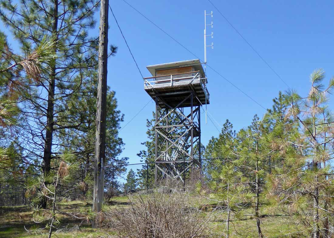
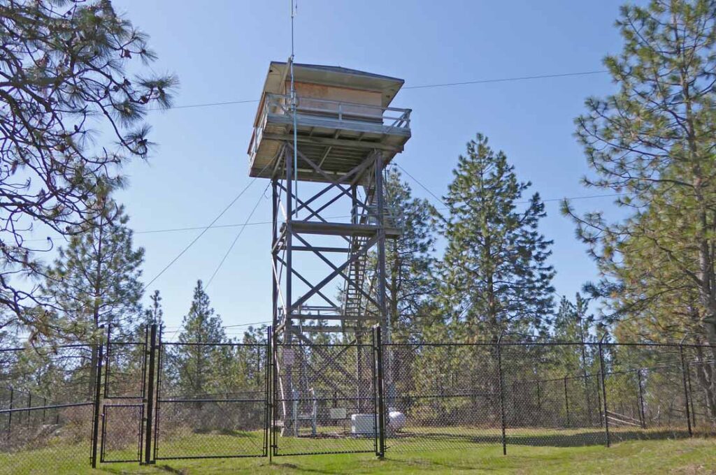
The re-located Lookout Point Lookout was then replaced by a nearly identical 40’ DNR wooden tower in 1976. This second Lookout Point Lookout is still there and is included in the SLOW93 Challenge list. The lookout was staffed each fire season from 1956-1992. It then was staffed again for one season in 1994 and has not been staffed since then. In 1999, the DNR Stated its intention to get rid of the unused Lookout Point Lookout. A series of articles in the FFLA’s Lookout Network discussed their intentions and Ray Kresek and the FFLA’s attempts to save the lookout and keep it in service:
LOOKOUT NETWORK Issue 10-3, Summer 1999: One Lookout Coming Down ……. The Washington DNR has is getting rid of another lookout — Lookout Point Lookout. Located 10 miles north of Spokane, the 1976 standard DNR 14′ x 14′ live-in flat top cab atop a 40-foot tower is in excellent condition. The lookout has not been regularly staffed for several years. Access had been very tightly controlled, but a new real estate development in the immediate area has opened the access to the site, undoubtedly a major factor in the removal decision. Information indicates that the lookout will given to an interested party at no cost. For more information, contact Ray Kresek at 509-466-9171.
LOOKOUT NETWORK Issue 10-4, Autumn, 1999: DNR CONTINUES LOOKOUT REMOVALS The FFLA is seeking to convince three Spokane County fire districts of the benefits if they were to staff the abandoned Lookout Point Lookout during periods of Red Flag weather and after lightning storms; a good assignment for their auxilliary members! If that doesn’t happen, yet another DNR tower will go in 2000. Located 10 miles from Spokane, the tower is in good shape and at least nine people are interested in it; so it shouldn’t go to waste if it must go.
LOOKOUT NETWORK Issue 11-1, Winter 2000: DNR TO GET RID OF TWO MORE: The DNR has announced plans for the decommissioning of two more lookouts; Lookout Point and Mount Spokane. The two lookouts in the Spokane area were last used in 1994. The DNR is considering three options: remove, sell (with removal required), or transfer ownership to the current landowner. Mount Spokane is located on State Parks Land; they have expressed an interest in retaining the lookout on site. Lookout Point’s disposition is uncertain.
LOOKOUT NETWORK Issue 12-4, Autumn, 2001: LOOKOUT POINT LOOKOUT: The DNR’s position is that since the lookout is no longer used for fire detection, their 3-acre lease with the land owners is no longer valid and the lookout should go. FFLA Director Ray Kresek has argued that since it is still in excellent condition, and could be opened on a 1-day notice, it IS still a fire lookout, but the DNR doesn’t agree. Ray is still trying to convince the three rural fire departments that they need to be involved.
Since the lookout still stands on Lookout Point, I asked Ray Kresek “Who now owns the lookout and who owns or pays for the lease of the land that it sits on?”. Ray wrote the following answer (somewhat edited), in a Jan. 3, 2023 email: “The DNR returned the tower to the landowner in 1999, as per the understanding made in 1956 with then WA State Division of Forestry Deer Park district fire warden Wayne Reiper and the Charter, Burchett, & Haggard landowner families. When no longer used for fire detection it would return to the landowner… The tower still stands, last I knew, occupied by Inland Power for their repeater. I believe they lease it from the Burchett family. I tried to work out a deal with DNR to staff LO Point and Mt Spokane with FFLA, SFD, and RFD volunteers, including me, to be paid on an AD hire card only during an active fire reported by the LO. It would’ve offered protection to Spokane city and 5 surrounding rural fire districts. The idea didn’t get any response from DNR, city, or any fire districts. More than likely because its next door neighbor … chased people off the hill with a shotgun and even held his neighbor at gunpoint until the sheriff came to arrest him for trespass. For as long as I can remember, LO staffers had trouble crossing his private land from the county road…”
Mica Peak LO moved to become Lookout Point LO


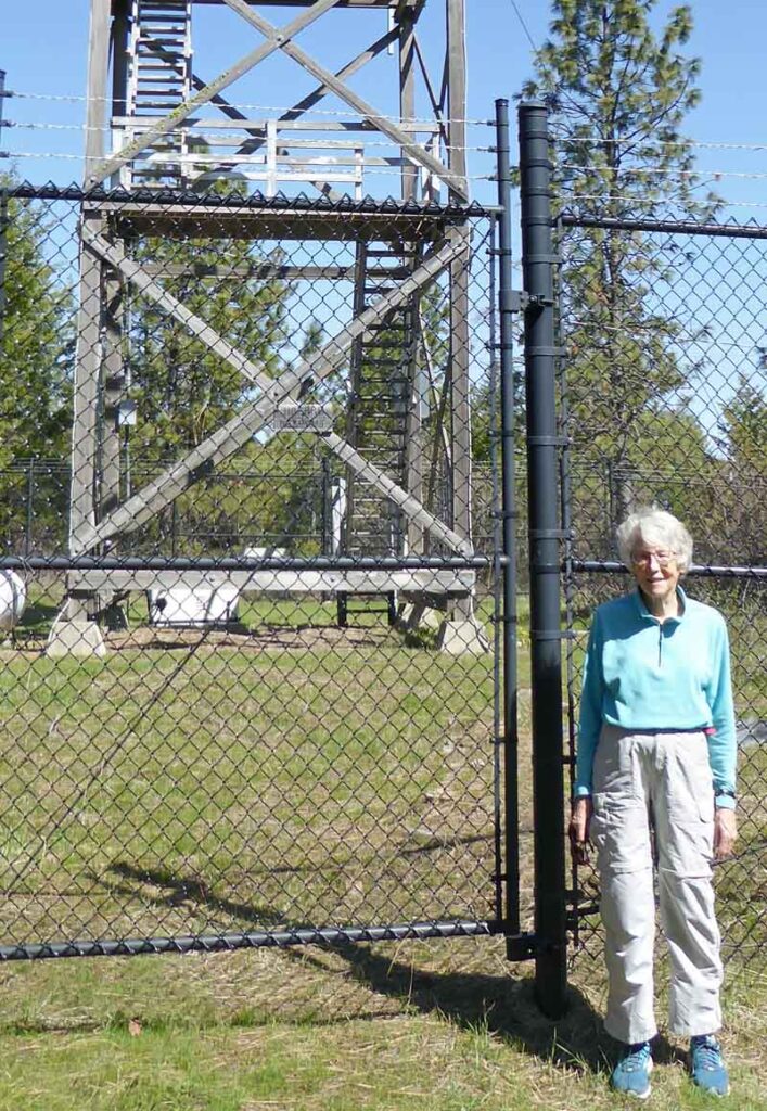
Our visit to the Standing Lookout Point Lookout ~ April 23, 2018
The Lookout Point Lookout is located on the 3120 foot northeastern summit of one of the many Lookout Mountains in the State of Washington. The re-located Mica Peak Lookout no longer exists as it was replaced by the current lookout in 1976. The replacement lookout was built from the same blueprints as the re-located Mica Peak lookout.
A gated development called River Bluff Ranch, which was started around 1999, has blocked direct public access to the lookout. We parked below the community’s locked gate and walked its roads to visit the tower.


Mica Peak Lookout Site, the Origin Site for the 1st Lookout Point LO
Still to be Visited
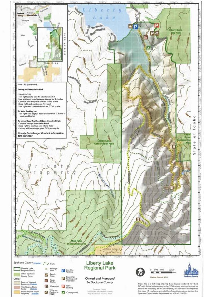
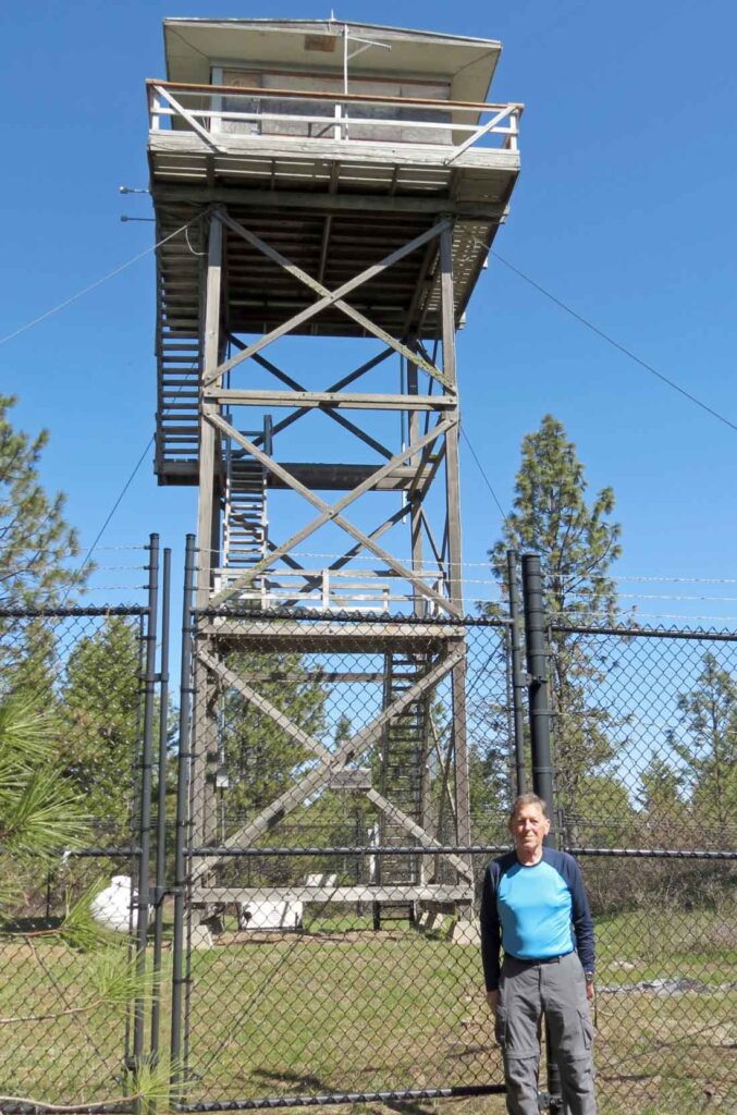
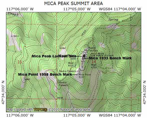
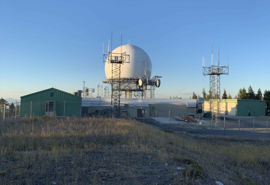
Mica Peak is the Southernmost peak in the Selkirk Mountain Range with a summit elevation of 5205 feet. There are several ways to walk or ride a mountain bike to near the top of Mica Peak. The routes all extend at least 9 miles round trip with up to 3000 feet elevation gain. The actual lookout site atop the peak is off limits as it is within the FAA’s No Trespassing Mica Peak Radar Station.
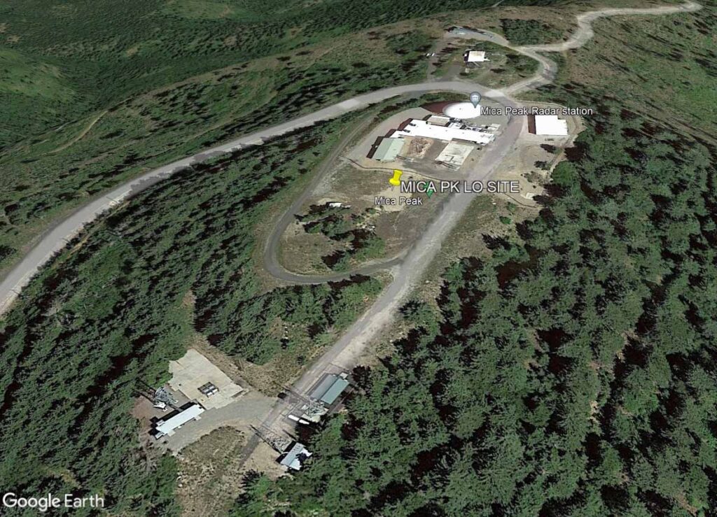
The first lookout atop Mica Peak, a 40 foot wooden tower with an 8’ x 8’ cab and ground cabin, was built in 1942. The 1942 lookout was replaced by a 40 foot wooden tower with live-in DNR cabin in 1954. In 1954, the Air Force selected the twenty acres atop Mica Peak which included the lookout site to be the Mica Peak Air Force Station. The construction of the station, a part of the Air Defense Command Mobile Radar Program, was begun and it became operational in 1956. The station was declared off limits to the public and guard stations were put in place. The lookout had to go as a radar dome was to be built on its site.
Over the years, the USAF added more radars to the station and in 1959 began performing air traffic control duties for the FAA. In 1979 the USAF shut down operations and transferred the site to the FAA who continue to use it for air traffic control. The site continued to be off limits to the public.
The location of the Mica Peak Lookout Site is known as the US Geological Survey (USGS) measured and documented the coordinates of the Mica Lookout Tower in 1952 (NGS SV1702 ~ Mica LOT). No bronze discs were set by the USGS as the lookout tower was the reference station. The MICA LOT NGS Data Sheet is labelled: “ NOTE – The station below is destroyed.” A 2020 Station Recovery Report reads “The Mica Peak Lookout Tower was taken down in 1954 and moved to Lookout Point.”
A Bronze Bench Mark Disc was placed on Mica Peak by the CGS in 1933 (NGS SV1194 ~ MICA). It has been reported that this disc which is labelled MICA 1933 is still in place. The lookout tower location is about 105 feet to the ENE of this disc.
The CGS measured and documented the location of one of the radar domes in 1965 (NGS SV1195 ~ Mica Peak Center Radar Dome). The NGS Data Sheet Station Description reads “ The Station is the top center of the center one of three large white radar domes on the highest point of Mica Peak.” No bronze discs were set at this location as the spherical radome was the reference station.
A comparison of the surveyed locations of the Lookout Tower and the Radar Dome, shown on a 2022 aerial photo below, shows how close that central radar dome had been built almost on top of the lookout site. The location of the MICA 1933 disc is also shown.
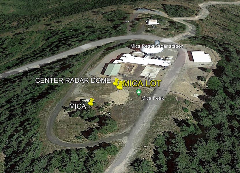
One thing that is obvious on the image above is that the USGS’s 1965 Radar Dome recorded location does not match the current FAA Radar Dome. This apparent error can be explained by looking at three older aerial photos. The earliest, taken in 1972, after the USGS measurement shows three radar towers with the central one apparently at the USGS measured location. The 1982 image shows a similar three radar dome configuration. In 1995, the USAF deactivated their air defense station and transferred the site to the FAA. The third aerial photo taken in 2009, years after this transfer, shows that two of the radar domes had been removed with the remaining one in the location shown in the 2022 Google Earth image.


There are several ways to walk or ride a mountain bike to near the top of Mica Peak. The most popular hike to a viewpoint near the radar station is through the Mica Peak Conservation Area. It starts at the Belmont Trailhead and follows a series of trails and old logging roads. Spokane County Park’s Mica Peak Conservation Area is a 1,794-acre mountainous, wilderness-like natural area on the west slopes of Mica Peak with views of the Spokane Valley and the Palouse.
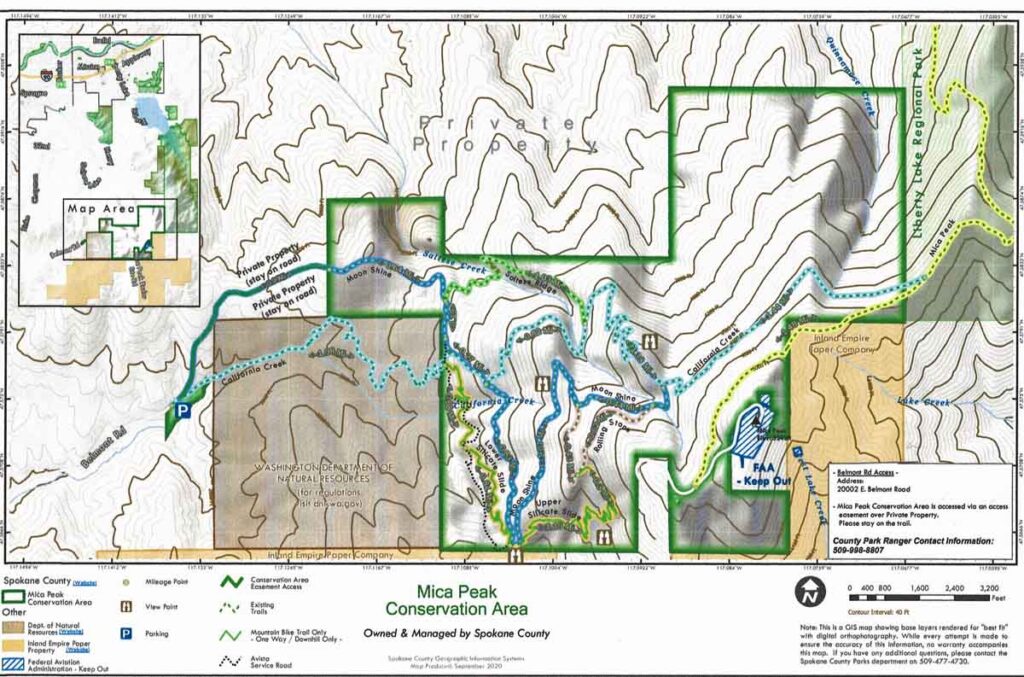
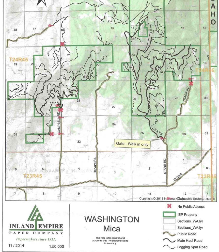
Mica Peak can also be reached from the south by walking the Radar Site Road from the Inland Empire Paper Company’s locked gate. An IEPC representative stated “The public does not need a permit in our walk-in-only nonmotorized area per our contract with the Washington Department of Fish and Wildlife.”
Another Mica Peak access route begins in Spokane County’s Liberty Lake Regional Park.